Øresund


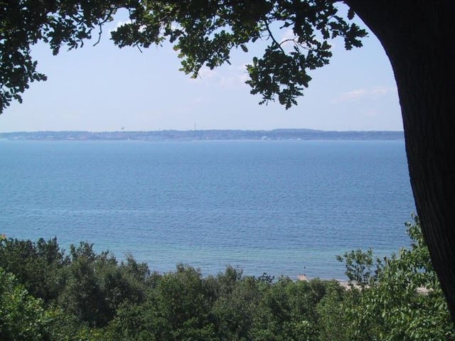
Denmark (Zealand) seen from the Swedish (Scania) side of Øresund
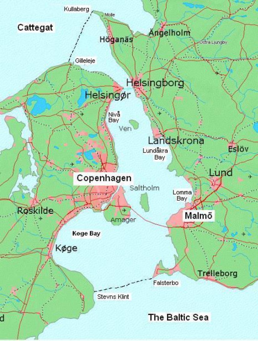
Øresund or Öresund (UK: /ˌɜːrəˈsʊnd/, US: /ˈɜːrəsʌn, -sʊnd, ˈɔːrəsʊnd/; Danish: Øresund [ˈøːɐsɔnˀ]; Swedish: Öresund [œrɛˈsɵnːd]), commonly known in English as the Sound, is a strait that forms the border between Denmark and Sweden, separating Zealand (Denmark) from Scania (Sweden). Stretching for 118 kilometers (73 miles), the width of the strait varies from 4 kilometers (2.5 miles) to 28 kilometers (17 miles), with its narrowest point measuring 4 kilometers (2.5 miles) between Helsingør in Denmark and Helsingborg in Sweden.
Øresund, along with the Great Belt, Little Belt, and Kiel Canal, is one of four waterways connecting the Baltic Sea to the Atlantic Ocean via Kattegat, Skagerrak, and the North Sea. It stands as one of the busiest water routes globally.
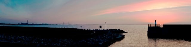
The Øresund Bridge, inaugurated on July 1, 2000, links the Danish capital Copenhagen with the Swedish city of Malmö, facilitating connectivity within a bi-national metropolitan area with close to 4 million inhabitants. Additionally, the HH Ferry route, operating between Helsingør, Denmark, and Helsingborg, Sweden, in the northern part of Øresund, ranks among the world’s busiest international ferry routes, with over 70 departures from each harbor daily.[8]
Geologically, Øresund is a relatively young strait, formed approximately 8,500 to 8,000 years ago due to rising sea levels. Previously, the Ancylus Lake, a freshwater body occupying the Baltic basin, had been connected to the sea solely via the Great Belt. The introduction of saltwater through Øresund marked the onset of the modern Baltic Sea as a saltwater body.[9]
Name
The strait is known as Øresund in Danish and Öresund in Swedish, commonly referred to as Sundet (meaning “the Strait”) in both languages. The name originates from two parts: “øre,” meaning gravel or sand beach, and “sund,” referring to a sound or strait.
The earliest recorded instance of the name dates back to around AD 1000 on a runestone, where it is written as “asura suti” and pronounced as Old East Norse /øːrasundi/ in the dative case. The Old West Norse and modern Icelandic form of the name is “Eyrarsund.” “Ör” is the modern form of the Old Norse word “aur,” signifying a gravel beach or shoal, which often forms a spit. This feature is prevalent in the area, and the term “ör” is evident in numerous place names along the strait, such as Helsingør, Skanör, Dragør, and Halör, all of which were significant trade centers during the Viking Age.
Boundaries
The northern boundary between Øresund and Kattegat extends from Gilleleje at the northern tip of Zealand to the westernmost point of Kullaberg, marked by Kullen’s Lighthouse, on the smaller peninsula north of Helsingborg known as Kullahalvön. To the south, the boundary toward the Baltic Sea begins at Stevns Klint, the westernmost point of the peninsula just south of Køge Bay, and continues to Falsterbo at the Falsterbo peninsula. The eastern boundary is defined by the Swedish coastline, while to the west, Amager may be considered part of Øresund, making it the largest island, or part of Zealand. Amager is connected to Zealand by eight links, including two street bridges, a road bridge, a motorway bridge, a dual-track railway tunnel, an underground metro, and a bicycle bridge. Additionally, it has a combined motorway and dual-track railway connecting it to Scania and Sweden.
Streams, animals and salinity
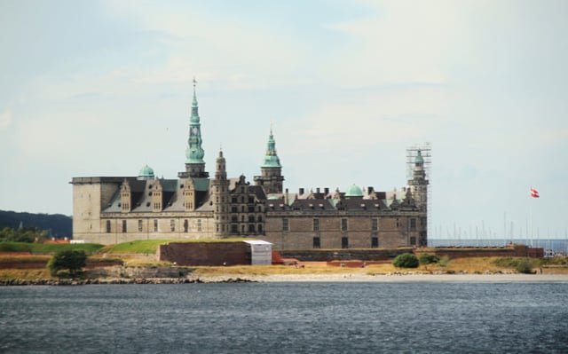
Kronborg castle is situated on the extreme northeastern tip of the island of Zealand at the narrowest point of the Øresund
Northern Øresund
Øresund, along with other Danish and Danish-German straits, marks the boundary between oceanic saltwater, with a salinity exceeding 30 PSU (Practical Salinity Units) or per mille by weight, and the considerably less saline Baltic Sea. .
As the Kattegat in the north has almost oceanic conditions and the Baltic Sea (around 7 PSU, in its main basin) has brackish water, Øresund’s water conditions are rather unusual and shifting. The streams are very complex, but thesurfacestream is often northbound (from the Baltic Sea) which gives a lower surface salinity, though streams can change from one day to another. Theaveragesurface salinity is about 10–12 PSU in the southern part but above 20 PSU north of Helsingør.
Near the seafloor of the Øresund, where the sea reaches sufficient depth, conditions tend to be more stable, and salinity levels typically remain consistently oceanic, measuring above 30 Practical Salinity Units (PSU). This stability in salinity is observed below a certain depth, which varies between 10 and 15 meters. In the southern part of the Øresund, outside the relatively narrow waterways of Drogden and Flintrännan, the depth typically ranges from 5 to 6 meters. This depth serves as the definitive border of oceanic saltwater, delineating the habitat for many maritime species of animals.
There are daily tides, but the lunar attraction cannot force much water to move from west to east, or vice versa, in narrow waters where the current is either northbound or southbound. So, not much of the difference in water levels in Øresund is due to daily tides, and other circumstances “hide” the little tide that still remains. The current has a much stronger effect than the tide on the water level, but strong winds may also affect the water level. During exceptional conditions, such as storms and hurricanes, oceanic water may suddenly flow into the Baltic Sea at all depths. Such events give deep waters in the southern Baltic Sea higher salinity, which makes it possible for cod to breed there. If no such inflow of oceanic water to the Baltic Sea occurs for around a decade, the breeding of cod becomes endangered.
Generally, when the current shifts from northbound to southbound, it never turns 180 degrees with the same flow, instead does the current “slow down to zero” and then begins to flow in opposite direction. (Local phenomenon close to shores, might differ from this general pattern)
History
Political control of the Øresund strait has been a significant aspect of Danish and Swedish history. Denmark historically held military dominance over the strait, with key coastal fortresses such as Kronborg in Elsinore on the west side and Kärnan in Helsingborg on the east side. These fortifications played a crucial role in maintaining Danish control over the strait. However, in 1658, the eastern shore of the Øresund was ceded to Sweden based on the Treaty of Roskilde. This marked a significant shift in control, as Sweden gained control over territory previously held by Denmark. Both Kronborg and Kärnan fortresses are strategically located at points where the strait is just 4 kilometers wide, underscoring their importance in controlling maritime traffic and defending against potential incursions.
In 1429, King Eric of Pomerania introduced the Sound Dues which remained in effect for more than four centuries, until 1857. Transitory dues on the use of waterways, roads, bridges and crossings were then an accepted way of taxing which could constitute a great part of a state’s income. The Strait Dues remained the most important source of income for the Danish Crown for several centuries, thus making Danish kings relatively independent of Denmark’s Privy Council and aristocracy.
To be independent of the Øresund, Sweden carried out two great projects, the foundation of Göteborg (Gothenborg) in 1621 and the construction of the Göta Canal from 1810 to 1832.
The Copenhagen Convention of 1857 abolished the Dues and made the Danish straits an international waterway.
A fixed connection was opened across the strait in 2000, the Øresund Bridge.
Notable islands
Denmark
-
Amager (western part is artificial enlargement from Øresund, or from Kalvebodene more precisely)
-
Saltholm
-
Peberholm – an artificial island
-
Middelgrundsfortet – an artificial island
-
Flakfortet – an artificial island
-
Amager Strandpark – an artificial beach area for Copenhagen
-
Brøndby Strandpark – an artificial beach area for Copenhagen in Køge Bugt
-
Vallensbæk-Ishøj Strandpark – an artificial beach area for Copenhagen in Køge Bugt
Sweden
-
Ven (Hven in Danish)
-
Gråen – an artificial island outside port of Landskrona (enlargements from Øresund in the 17th and 20th centuries)
Notable Bights
Denmark
-
Køge Bugt (Køge Bay)
-
Nivå Bugt (Nivå Bay)
-
Kalveboderne
Sweden
-
Lundåkrabukten (Lundåkra Bay)
-
Lommabkten (Lomma Bay)
-
Höllviken
See also
References
[1]
Citation Linken.oxforddictionaries.com“Øresund” (US) and “Øresund”.Oxford Dictionaries. Oxford University Press. Retrieved February 6, 2019.
Oct 2, 2019, 1:20 AM
[2]
Citation Linkwww.merriam-webster.com“Øresund”.Merriam-Webster Dictionary. Retrieved February 6, 2019.
Oct 2, 2019, 1:20 AM
[3]
Citation Linkwww.ahdictionary.com“Øresund”.The American Heritage Dictionary of the English Language(5th ed.). Boston: Houghton Mifflin Harcourt. 2014. Retrieved February 6, 2019.
Oct 2, 2019, 1:20 AM
[4]
Citation Linkwww.dmi.dk“Bælthavet og Sundet” (in Danish). Danish Meteorological Institute. Retrieved 30 March 2013.
Oct 2, 2019, 1:20 AM
[5]
Citation Linkwww.britannica.com“The Sound.”Encyclopædia Britannica. 12 March 2004. Retrieved 20 April 2017.
Oct 2, 2019, 1:20 AM
[6]
Citation Linkbooks.google.comGluver, Henrik; Dan Olsen (1998). “2.7 Øresund Bridge, Denmark-Sweden”.Ship Collision Analysis. Rotterdam: A. A. Balkema. ISBN 90-5410-962-9. Øresund (the Strait) is, like the Great Belt, an important water way for the international ship traffic between the North Sea and the Baltic Sea.
Oct 2, 2019, 1:20 AM
[7]
Citation Linkwww.tendensoresund.orgThe region has a population of 3,894,365 (2015) and a population density of 187/km². “Geography”. Tendens Øresund. Retrieved 29 October 2010.. On 1 January 2016 the name of the region was changed to “Greater Copenhagen and Skåne” by the Øresund Committee.
Oct 2, 2019, 1:20 AM
[8]
Citation Linkwww.scandlines.se“At Scandlines”. press “Tidtabell 2 jan-31 maj 2015”, PDF file.
Oct 2, 2019, 1:20 AM
[9]
Citation Linkwww.pgi.gov.plBjörck, Svante; Andrén, Thomas; Jensen, Jørn Bo (2008). “An attempt to resolve the partly conflicting data and ideas on the ancylus-Littorina transition”.Proceedings of the Workshop “Relative sea level changes”. Polish Geological Institute Special Papers.23. pp. 21–26.
Oct 2, 2019, 1:20 AM
[10]
Citation Linkruneberg.org“141-142 (Nordisk familjebok / Uggleupplagan. 34. Ö – Öyslebö; supplement: Aa – Cambon)”.runeberg.org(in Swedish). 1922. Retrieved 2017-10-17.
Oct 2, 2019, 1:20 AM
[11]
Citation Linkopenlibrary.orgMejlbystenen, DR 117. ᛬ᛁ᛬ᚢᚱᛅ᛬ᛋᚢᛏᛁ᛬ “in the ear-sound”.
Oct 2, 2019, 1:20 AM
[12]
Citation Linkwww.dr.dkØreOrdbog over det danske Sprog“et smalt stykke land imellem to store vande, fra et land til andet. […] Øresund kaldes saaledes fordi det begynder ved Siellands Øre og ved Øster-Søen ved et Øre, som er Skan-Øre. […] sandet ell. gruset strand(bred), ofte spec.: dannende en odde, en halvø ell. en smal landtange.” Katlev, Jan (2000).Politikens Etymologisk Ordbog. Copenhagen: Politikens Forlag. p. 694. ISBN 87-567-6200-3. afør,øre‘gruset strandbred’ + sund. Ør,Ordbog over det danske Sprog. C.f. also Ole Lauridsen in the Danish radio programSproghjørnet(audio clip in Danish).
Oct 2, 2019, 1:20 AM
[13]
Citation Linksv.wikipedia.orgSvensk Ordbokpublished by the Swedish Academy “Ör: (bank av) grus eller sand […] sedan 1000-talet runsten, Funbo, Uppland (Sveriges runinskrifter) runform aur, fornsv. ör, sv. dial. ör ’grus, sten’”
Oct 2, 2019, 1:20 AM
[27]
Citation Linkwww.pgi.gov.pl“An attempt to resolve the partly conflicting data and ideas on the ancylus-Littorina transition”
Oct 2, 2019, 1:20 AM
[28]
Citation Linkruneberg.org“141-142 (Nordisk familjebok / Uggleupplagan. 34. Ö – Öyslebö; supplement: Aa – Cambon)”
Oct 2, 2019, 1:20 AM
[36]
Citation Linken.wikipedia.orgThe original version of this page is from Wikipedia, you can edit the page right here on Everipedia.Text is available under the Creative Commons Attribution-ShareAlike License.Additional terms may apply.See everipedia.org/everipedia-termsfor further details.Images/media credited individually (click the icon for details).
Oct 2, 2019, 1:20 AM