Åfjord
Åfjord
|
Åfjord kommune
|
|
|---|---|
|
Municipality
|
|
 Coat of arms  Trøndelag within Norway |
|

Åfjord within Trøndelag
|
|
| Coordinates:63°58′40″N 10°23′08″E[15] | |
| Country | Norway |
| County | Trøndelag |
| District | Fosen |
| Established | 1 Jan 1838 |
| Administrative centre | Årnes |
| Government | |
| • Mayor(2007) | Vibeke Stjern (Ap) |
| Area | |
| • Total | 954.66 km2(368.60 sq mi) |
| • Land | 895.27 km2(345.67 sq mi) |
| • Water | 59.39 km2(22.93 sq mi) 6.2% |
| Area rank | 114 in Norway |
| Population
(2018)
|
|
| • Total | 3,277 |
| • Rank | 252 in Norway |
| • Density | 3.7/km2(10/sq mi) |
| • Change(10 years) | 1.4% |
| Demonym(s) | åfjording[1] |
| Time zone | UTC+01:00 (CET) |
| • Summer (DST) | UTC+02:00 (CEST) |
| ISO 3166 code | NO-5018 |
| Official language form | Neutral |
| Website | afjord.kommune.no[16] |
|
Data from Statistics Norway[17]
|
|
Åfjord is a municipality situated in Trøndelag county, Norway, within the Fosen region. The administrative center of the municipality is the village of Årnes. Other notable villages in Åfjord include Revsnes, Harsvika, and By. Located on the northwestern side of the Fosen peninsula, Åfjord lies northwest of the city of Trondheim. It is positioned between the municipalities of Bjugn and Roan, with Verran to the west and Indre Fosen to the south.[2]
Covering an area of 955 square kilometers (369 sq mi), Åfjord ranks as the 114th largest municipality in Norway by area. With a population of 3,277 inhabitants, it is the 252nd most populous municipality in the country. The population density of Åfjord is approximately 3.7 inhabitants per square kilometer (9.6/sq mi), experiencing a 1.4% increase over the past decade.[3][4]
|
Åfjord kommune
|
|
|---|---|
|
Municipality
|
|
|
Coat of arms Trøndelag within Norway |
|
|
Åfjord within Trøndelag
|
|
| Coordinates:63°58′40″N 10°23′08″E[15] | |
| Country | Norway |
| County | Trøndelag |
| District | Fosen |
| Established | 1 Jan 1838 |
| Administrative centre | Årnes |
| Government | |
| • Mayor(2007) | Vibeke Stjern (Ap) |
| Area | |
| • Total | 954.66 km2(368.60 sq mi) |
| • Land | 895.27 km2(345.67 sq mi) |
| • Water | 59.39 km2(22.93 sq mi) 6.2% |
| Area rank | 114 in Norway |
| Population
(2018)
|
|
| • Total | 3,277 |
| • Rank | 252 in Norway |
| • Density | 3.7/km2(10/sq mi) |
| • Change(10 years) | 1.4% |
| Demonym(s) | åfjording[1] |
| Time zone | UTC+01:00 (CET) |
| • Summer (DST) | UTC+02:00 (CEST) |
| ISO 3166 code | NO-5018 |
| Official language form | Neutral |
| Website | afjord.kommune.no[16] |
|
Data from Statistics Norway[17]
|
|
General information
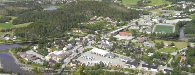
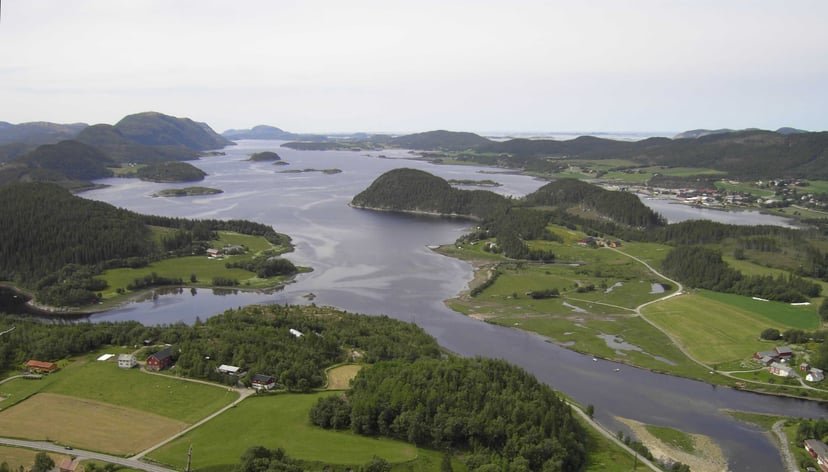
Årnes in Åfjord
The municipality of Aafjord was established on 1 January 1838, as part of the formannskapsdistrikt system. However, on 26 March 1870, a royal resolution transferred a small, uninhabited area from Aafjord to the neighboring municipality of Bjugn. Then, on 1 January 1896, the southwestern coastal region of Aafjord, with a population of 1,529, was separated to create the new municipality of Jøssund. This reduced Aafjord’s population to 2,419 residents. Simultaneously, on the same date, the name of Aafjord municipality was changed to simply “Aa”. Later, the spelling was altered to “Å”. On 13 July 1934, the municipality’s name was once again changed, this time to “Åfjord”. From that point forward, the administrative center in the municipality has been referred to as “Å” or “Å i Åfjord”.
During the 1960s, there were many municipal mergers across Norway due to the work of the Schei Committee. On 1 January 1964, the neighboring municipalities of Stoksund (population: 2,643) and Åfjord (population: 1,515) to form the new, larger municipality of Åfjord.[5]On 1 November 1980, the postal service changed the name of the municipal center from“Å i Åfjord”to“Årnes”.
On 1 January 2018, the municipality switched from the old Sør-Trøndelag county to the new Trøndelag county.
Name
The municipality is named after the Åfjorden. The first element is the name of the farm and the churchsiteÅ(Old Norse:Ár). This name is the plural form ofáwhich means “river”, probably since there are two rivers, the Norddalselva and Stordalselva, that run together south of the farm.[8]The name has varied over the years:Aafjord(1838 to 1896), thenAaorÅ(1896 to 1934), and finallyÅfjord(since 1934).
Coat of arms
The coat of arms of Åfjord was granted in 1997. The arms feature two stems of a boat, representing the unique boats known as the Norwegian “Åfjordbåt” that are traditionally constructed in the municipality.[9]
Churches
The Church of Norway has two parishes (sokn) within the municipality of Åfjord. It is part of the Fosen prosti (deanery) in the Diocese of Nidaros.
| Parish (sokn) | Church Name | Location of the Church | Year Built |
|---|---|---|---|
| Åfjord | Åfjord Church | Årnes | 1879 |
| Stoksund | Stoksund Church | Revsnes | 1825 |
History
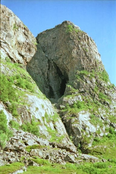
Harbakkhula (cave), with evidence of stone age settlement.
There are archeological findings on many sites across the municipality. On Dragseid archaeologists have located grave mounds. On Dragseid it is said that the wooden boats were dragged over this thin peninsula to shorten the journey and to avoid risking them in bad weather. Up to the Middle Agesthe Fosen peninsula was included as a part of the district of Nordmøre, immediately to the south.[10]
Prior to 1950, there were no roads leading into and out of the municipality. In 1950, the road to the neighboring municipality of Bjugn to the south was finally finished. In 1955, the road to Stokksund in the northern part of the municipality was finished.
An old type of wooden boat, the Åfjord boat, comes from this area. The boat is a direct descendant form the old Norse Viking boats. It is still being produced, although in very small numbers. The boat is rounded at both ends. It is known to be a good coastal sailer. Different sizes exist. From the small “faering” to the largest of them all, the “fembøring”.
Government
All municipalities in Norway, including Åfjord, are responsible forprimary education(through 10th grade), outpatienthealth services, senior citizen services,unemploymentand othersocial services, zoning, economic development, and municipalroads. The municipality is governed by a municipal council of elected representatives, which in turn elect amayor.[11]The municipality falls under the Fosen District Court and the Frostating Court of Appeal.[11]
Municipal council
The municipal council (Kommunestyre) of Åfjord is made up of 21 representatives that are elected to four year terms. Currently, thepartybreakdown is as follows:[12]
| Party Name | Name in Norwegian | Number of representatives |
|
|---|---|---|---|
| Labour Party | Arbeiderpartiet | 8 | |
| Progress Party | Fremskrittspartiet | 2 | |
| Conservative Party | Høyre | 3 | |
| Christian Democratic Party | Kristelig Folkeparti | 2 | |
| Centre Party | Senterpartiet | 5 | |
| Liberal Party | Venstre | 1 | |
| Total number of members: | 21 | ||
Economy
The people of Åfjord make their living fromagriculture, forestry, fishing, transport (sea and land),aquaculture(fish and shellfish), construction, and services. The largest employer in the area is Stjern (forestry, sawmill, entrepreneur). The contractor, building, sector now employs about 19% of the working force, and is now larger than the agricultural sector.
Geography
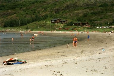
Hosensanden beach on the island Stokkøya, July 1987
The major centre of the municipality isÅrnes(also called “Å in Åfjord“). All major services of the municipality are located there. Other populated areas areMonstad/Å, a couple of minutes by car from Årnes, andStoksund/Revsnes. Åfjord covers an area of approximately 1,000 square kilometres (390 sq mi), with about 3200 residents— about one third of which live in the Årnes urban area. During the last decades there has been a decrease of 100-150 people yearly. Many young people leave the municipality for school, university or work.
Åfjord consists of many small settlements—from the islands in the west to the highlands in the east. Traditionally, Åfjord has been an agricultural society, while Stoksund in the west has had a more of a fishing-based economy. There is an increasing amount of weekend houses and recreational cabins in the area. Åfjord has two big islands; Stokkøya (380 inhabitants) and Linesøya (80 inhabitants). Stokkøya is connected with the mainland through a bridge Stokkøy Bridge. The Linesøy Bridge connects the islands of Stokkøya and Linesøya. The other main island is Lauvøya near the south at the end of the Åfjorden.
The highest point in Åfjord is the 676-metre (2,218 ft) tall Finnvollheia. There are over 1,000 lakes with fish. Åfjord also has two major salmon rivers—the Nordalselva and Stordalselva, which flow into Åfjorden. English Lords used to fish here in the late 19th century. The lake Stordalsvatnet lies just east of Årnes. The lake Straumsetervatnet lies in the east, along the border with Verran.
References
[1]
Citation Linkwww.sprakradet.no“Navn på steder og personer: Innbyggjarnamn” (in Norwegian). Språkrådet. Retrieved 2015-12-01.
Oct 2, 2019, 12:04 AM
[2]
Citation Linksnl.noThorsnæs, Geir, ed. (2017-05-17). “Åfjord”.Store norske leksikon(in Norwegian). Kunnskapsforlaget. Retrieved 2017-10-07.
Oct 2, 2019, 12:04 AM
[3]
Citation Linkwww.ssb.noStatistisk sentralbyrå (2018). “Table: 06913: Population 1 January and population changes during the calendar year (M)” (in Norwegian). Retrieved 2019-03-12.
Oct 2, 2019, 12:04 AM
[4]
Citation Linkwww.ssb.noStatistisk sentralbyrå. “09280: Area of land and fresh water (km²) (M)” (in Norwegian). Retrieved 2019-03-12.
Oct 2, 2019, 12:04 AM
[5]
Citation Linkwww.ssb.noJukvam, Dag (1999). “Historisk oversikt over endringer i kommune- og fylkesinndelingen” (PDF) (in Norwegian). Statistisk sentralbyrå.
Oct 2, 2019, 12:04 AM
[6]
Citation Linkwww.afjord.kommune.no“Ny kommune” (in Norwegian). Åfjord kommune. Retrieved 2017-10-07.
Oct 2, 2019, 12:04 AM
[7]
Citation Linkwww.roan.kommune.noHauknes, Joar (2017-12-21). “Åfjord blir navnet på den nye kommunen” (in Norwegian). Åfjord kommune.
Oct 2, 2019, 12:04 AM
[8]
Citation Linkbooks.google.comRygh, Oluf (1901).Norske gaardnavne: Søndre Trondhjems amt(in Norwegian) (14 ed.). Kristiania, Norge: W. C. Fabritius & sønners bogtrikkeri. p. 23.
Oct 2, 2019, 12:04 AM
[9]
Citation Linkwww.afjord.kommune.no“Åfjord kommunes kommunevåpen” (in Norwegian). Åfjord kommune. Retrieved 2008-10-28.
Oct 2, 2019, 12:04 AM
[10]
Citation Linkarkeologi.blogspot.comStylegars, Frans-Arne H. (2006-05-14). “Fosens historie frem til 1730” (in Norwegian). Arkeologi i Nord. Retrieved 2017-10-07.
Oct 2, 2019, 12:04 AM
[11]
Citation Linksnl.noHansen, Tore, ed. (2016-05-12). “kommunestyre”.Store norske leksikon(in Norwegian). Kunnskapsforlaget. Retrieved 2019-01-01.
Oct 2, 2019, 12:04 AM
[12]
Citation Linkwww.ssb.no“Table: 04813: Members of the local councils, by party/electoral list at the Municipal Council election (M)” (in Norwegian). Statistics Norway.
Oct 2, 2019, 12:04 AM
[20]
Citation Linkwww.ssb.no“Table: 06913: Population 1 January and population changes during the calendar year (M)”
Oct 2, 2019, 12:04 AM
[22]
Citation Linkwww.ssb.no“Historisk oversikt over endringer i kommune- og fylkesinndelingen”
Oct 2, 2019, 12:04 AM
[29]
Citation Linkwww.ssb.no“Table: 04813: Members of the local councils, by party/electoral list at the Municipal Council election (M)”
Oct 2, 2019, 12:04 AM
[32]
Citation Linken.wikipedia.orgThe original version of this page is from Wikipedia, you can edit the page right here on Everipedia.Text is available under the Creative Commons Attribution-ShareAlike License.Additional terms may apply.See everipedia.org/everipedia-termsfor further details.Images/media credited individually (click the icon for details).
Oct 2, 2019, 12:04 AM